
Pringle Bay is positioned within the Transition Zone of the Kogelberg Biosphere Reserve and was registered as a Conservancy in December 2005. As residents, visitors, property and business owners we therefore have a mutual and critical responsibility to protect and preserve the flora and fauna within our village and within the pristine natural environment which surrounds us.
The first Primary Goal supporting our Vision for Pringle Bay is “To preserve our community’s distinctive cultural and natural heritage and unique lifestyle”. In line with this goal, which stretches more broadly than the natural environment, the PBRA’s extensive Conservation Management Plan also encompasses lifestyle and cultural elements.
Andre Nel Photography
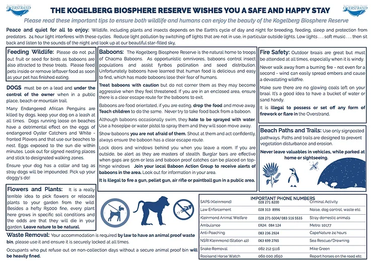
There are many things that we can do to ensure that both wildlife and humans can enjoy the beauty of the Kogelberg Biosphere.
Click on the image to download this informative poster provided by Overstrand Municipality.
We encourage all Guesthouses, B&B’s, Airbnb’s and rental agents to download, print and display this information for their guests.
Pringle Bay’s beautiful beach sand is at risk of being lost if steps are not taken to safeguard the existing sand, and to encourage dune stabilisation and growth. To this end a Beach and Dune Maintenance Management Plan (MMP) was approved by the authorities in 2016 and is to be completed in 5 phases ideally over 2 to 3 years. The key objective is to reinstate the natural beach and foredune volume of sand that forms the natural buffer against sea storms, and especially to combat future sea level rise and climate related changes. Beach sand has been gradually lost to the system due to the development of Pringle Bay town which effectively cut-off the sand supply to the beach from the historic dune field.
A Beach Rescue Group, made up of hardworking and committed volunteers, meets on a regular basis to work on this initiative and their efforts have shown encouraging results. The team collaborates with Overstrand Municipality which assists with the supply of beach signage and poles to clearly mark pathways.
Beach Rescue work is scheduled for every 2nd Saturday of each month from 08:30 until 11:30, getting together at the William Road parking area. Work broadly entails the dragging and placement of branches, seasonal planting of vegetation and the maintenance of our footpaths’ rope fencing. Residents are advised to join the Pringle Bay Beach Rescue WhatsApp Group in order to get notifications of planned activities and the sharing of relevant information. The Group is led by Carel Laubscher and you can reach him at 079 5244334. More volunteers are always welcome!
Beach and Dune Maintenance Management Plan (MMP)
By Laurie Barwell
The Beach and Dune Maintenance Management Plan (MMP) was approved by the authorities in 2016 and is to be completed in 5 phases ideally over 2 to 3 years. The key objective is to reinstate the natural beach and foredune volume of sand that forms the natural buffer against sea storms and especially to combat future sea level rise and climate related changes.
Beach sand has been gradually lost to the system due to the development of Pringle Bay town which effectively cut-off the sand supply to the beach from the historic dunefield. Of significance is that the position of the waterline of the typical summer beach moved landwards at a rate of almost 3 m per year totalling 130 m between 1938 and 1987, as determined through historic aerial photo analysis.
Pringle Bay is categorised as a ‘pocket beach’ system and relatively little ‘new’ sand is brought onto the beach (either from the sea or from the river). This means that the sand on the beach and dunes is finite and is all that is available to combat the forces of the sea now and into the future!
It is the high velocity northwesterly winds (during the winter months) that move significant volumes of wind-blown sand off the beach and dunes towards the village. Uncontrolled sand blown eastward off the beach and foredune is essentially ‘lost’ to the pocket beach system, resulting in a gradual reduction in the sea-storm buffering ability of the beach and dune system. This will result in the continued and significant loss of beach area if left unchecked.
The eastward blown sand has formed the high mobile dunes that, if left as-is, will continue moving slowly towards (and over/into) the houses, roads, parking areas and the established wetlands. Although some of the sand is returned to the beach by the opposing south-easterlies prevailing during the spring and summer months, the net dune migration is towards the east. More detail of the prevailing natural processes can be found in the two management reports available on request from the Ratepayers Association.
Because humans have changed the functioning of the natural system (through stabilising the natural dunefield for development), human intervention through active management (guided by the MMP) is needed to restore the balance in the sand system. The key to restoring and sustaining this balance lies in keeping the sand within reach of the coastal processes, that is, on the beach and in the dynamic foredunes where it is stored in readiness to counter high energy storm erosion.
The first phase of the MMP focused on the middle section of the beach and consisted of packing branches in strategic places to stop wind-blown sand from moving inland off the beach and foredune. The branches were obtained from local hacking activities. Phase 1 was ably carried out by local resident and volunteer, Mr Chris Geldenhuys and his team of energetic labourers during the period up to May 2017.
In the 18 months, they managed to keep an estimated 10 000 cubic metres of sand within the beach and foredune area. This equates to around 1500 truckloads of sand – all done by combining human power (packing sand trapping branches in strategic places identified in the MMP) and the natural wind energy that moves the sand. Significant progress has also been made with the establishment of the planned stormwater detention area that will in time develop into a coastal wetland and attractive educational focus as per the MMP. Work is now needed to open an effective stormwater drainage channel from the existing stormwater pipe outlet to the detention area. This is required to channel stormwater from the public parking area to the new wetland.
The post-winter beach and dune profiles survey done on 29 October 2017 show that the position and profile of the new foredune is rapidly approximating the design profile. In the MMP the design top level of the foredune is 6 metres above the benchmark of Mean Sea Level (MSL) and the foredune base width is designed to be 40 m to 45 m back from the +2 m MSL contour line on the beach. The actual dimensions are approximately + 5m MSL top level and a base width of between 20 m and 35 m. An aerial photo analysis for the period March 2005 to May 2017 shows that the position of the sea level wetline has stabilised and moves within a band of 5 m, at the southern end of the beach, 15m in the middle section and 25 m at the northern end next to the estuary mouth. This holds for both the winter and summer periods.
Observers would have noticed that the beach is at its widest at the end of summer (April) and significantly narrower by October as a result of the erosion by high energy winter storm processes. In fact the position of the western wetline changes within a band of
30 m at the southern end of the beach and 80 m at the estuary end of the beach. (A youtube video describing the coastal processes can be seen at https://www.youtube.com/ watch?v=L5vcWnLehWw ).
No branch packing will be done on the foredunes during the period up to May 2018 as the south-easterlies will assist in moving sand westwards from the foredunes back onto the beach as planned. The kelp washed up on the upper beach is a natural sand-trap, forming a microclimate and nursery area for dune vegetation. Furthermore, valuable natural fertiliser is provided as the kelp dries out and is naturally broken down through a process of microbial biodegradation thereby enhancing vegetation growth. The removal of this free natural product should be discouraged as indicated in the MMP.
The core activity of Phase 2 is the mechanical movement of the accumulated sand in the high dunes back onto the beach during March and April 2018. This is dependent on sourcing funding to do this. If no funding for Phase 2 is found, this important long-term management action will have to be undertaken at a later time.
Phase 3 of the MMP needs to be undertaken in May and June 2018 and requires continued branch-packing to again trap the eastbound sand blowing off the beach in winter to build up the foredune to the required +6 m MSL level. Planting of dune vegetation (as per the MMP) should commence in July 2018 and continue until the end of September at the latest. The normal winter rainfall will enable the vegetation to grow and become established as a naturally functioning foredune within one or two seasons. The continued use of the demarcated beach access pathways by beach-goers is encouraged. It is also important to keep people off the new foredunes so-as to protect the fragile young dune plants that are easily damaged by human trampling.
The physical facts on site leaves one with little doubt that elements of the first phase of the implementation of the MMP are highly successful.
This is mainly due to the oversight and ongoing efforts by the dune management team who deserve their well-earned recognition. Ratepayers and their family members are encouraged to join in, lend a helping hand and ensure that the picturesque Pringle Bay pocket beach is sustained for future generations to also enjoy.
Baboons do enter the village and can be seen on the roads, occasionally on the dunes, in the business area and on private property. For this reason, it is crucial to keep household waste in baboon-proof bins (which is a mandatory requirement by the municipality) and secure homes by putting baboon-proof measures in place.
Taking these precautionary measures are key to avoiding the creation of easy access to human food, the primary reason that many baboons enter the village, and to avoiding human-baboon conflict as much as possible.
These are a few critical Do’s and Don’ts to abide by:
Overstrand Municipality(OM) has the mandate and is responsible for baboon management in the Overstrand region. In July 2020 they appointed Human Wildlife Solutions (HWS) for a three-year period to manage the Baboon Program in towns with human-wildlife conflict, Pringle Bay being one of them. This program expired at the end of June 2023.
OM advertised a new tender in March 2023 with a closing date of April 26 2023. On the 29th June 2023 OM reported that no successful bids were received and that they cancelled the Baboon Management Tender for the 2023/24 financial year. The contract of the current service provider, HWS, was extended until December 2024 for the Hermanus area.
For Pringle Bay, Betty’s Bay and Kleinmond, OM has taken ownership of the baboon management programme themselves. They deploy Eco-Rangers in the village, armed with vuvuzelas and red flags to warn residents of baboons in the neighbourhood. According to OM’s press release at the time: “The approach will be to steer the baboons out of the urban area, with the focus on the current Early Warning System, and also waste management and public education.” It has been confirmed by OM that residents can request the Eco-Rangers’ help in getting baboons out of their houses and that they will provide that assistance when asked by the resident.
OM’s stated staffing plan for Pringle Bay is to deploy a team consisting of 1 Area Manager, 3 Supervisors and 12 Eco-Rangers. The staff are to be trained and they’ll work in 2 shifts once fully deployed. Their winter hours will be 7am to 6pm, summer hours will be 7am to 7pm.
Residents can join the Baboon Alerts Telegram group to receive and share information on the animals’ whereabouts, thereby alerting those in the vicinity to secure doors and windows.
To join, use this link on your cell phone browser https://t.me/+WKGmNlTYiv0zNTI8 OR email info@pringlebayratepayers.co.za with your name, cell phone number and ERF number.
The purpose of the Hack Group is to eradicate, or at the very least, to limit the growth and spread of invasive alien vegetation in the area with a view to protecting the natural fynbos. That is being done by cutting down and poisoning or uprooting alien plants and trees. Many of the trees are too thick to cut by means of a handsaw and for that reason, a chainsaw is used. The vegetation that is targeted consists mainly of Rooikrans (Acacia cyclops), Port Jackson (Acacia saligna), Pepper Wattle (Acacia longifolia), Australian Myrtle (Leptospernumlaevigatum), New Zealand Christmas Trees (Metrosideros excels), Black Wattle (Acacia mearnsii), Pine Trees (Pinuspinaster), and many others listed in the schedules of the relevant conservation legislation.
The Hack Group meets on the last Saturday of the month in Pringle Bay and focuses on chosen areas in Pringle. In addition, some members, in conjunction with members of the Betty’s Bay Hack Group and Rooi Els, form a weekly Wednesday Hack. They hack where the threat is most urgent within the Kogelberg Biosphere area. It is essential that all residents of the Kogelberg Biosphere take note of the National Environmental Management: Biodiversity Act (NEMBA), Environmental Impact Assessment Regulations of October 2014. It is our duty to ensure that we secure our heritage, the fynbos, for the generations to come. There are some stiff penalties for landowners who do not comply with the eradication of invasive exotics. The sooner you address the invasion, the easier and cheaper it is to address!
Anyone who wants to become involved in the fight against the invading exotics is welcome, all ages, shapes and sizes can make a contribution. All you need to provide are sturdy shoes and gloves. Feel free to liaise with Chris Geldenhuys (082 900 8299), the Hack Convenor for Pringle Bay.
2026© Pringle Bay Ratepayers' Association. All rights reserved. Website Designed by Thalleon Designalytics